
If you’re planning a visit to one of California’s renowned national parks, the Chimani apps are sure to help you plan your trip and navigate the parks like a pro. But, if like many, you haven’t settled on which park or parks you want to visit while in The Golden State, here is some information you’ll want to know when narrowing your selection. California is home to eight national parks, Channel Islands, Death Valley, Joshua Tree, Lassen Volcanic, Pinnacles, Redwood, Yosemite, and the sister parks of Sequoia & Kings Canyon.
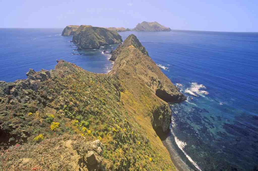
The Channel Islands consist of five unique islands, all outstanding in their own right. Free admission and open year-round, exploring Santa Cruz, Anacapa, Santa Rosa, Santa Barbara, and San Miguel Islands can always make for a good day or weekend trip for the family. If you’re looking for a more challenging experience during your visit to the park, backcountry camping is available at the Del Norte campsite on Santa Cruz Island, and at certain times of the year on Santa Rosa Island.
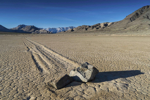
Death Valley is the largest of California’s national parks with over three million-acres of land. It is accessible by car, which will be necessary to get around, and there is an entrance fee of $20 per vehicle. Death Valley is one of the driest, hottest, and lowest places in the world, making its summer climate easily one of the harshest. While Death Valley is open year-round, most choose to visit during the winter months when the temperatures average in the high sixties. While the lowest point in the park is 282 feet below sea level, the park’s highest point, Telescope Peak, sits at 11,049 feet. This great range in elevation allows Death Valley’s unique biome to support a great diversity of life (despite what its name would suggest). Whenever you choose to visit the park it is always wise to come prepared with plenty of water and a full tank of gas. Drive safely!

The best time to visit Joshua Tree National Park is during the spring and fall when moderate temperatures prevail. Although mountain bikes and four wheel drive vehicles can make use of unpaved country backroads to explore the park, use is fairly limited. While hiking, park rangers ask that visitors keep to the pre-established trails for their own safety and preserve the natural state of the park. The eponymous Joshua trees can be seen throughout the park alongside over 800 additional species of plants. The tallest Joshua tree in the park is in the Queen Valley Forest, and stands an imposing 40 feet high.
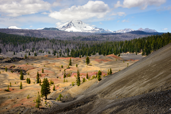
Containing 30 volcanic peaks, Lassen Volcanic National Park offers the opportunity to see the devastating results of relatively recent volcanic activity on the landscape along with still-active steam vents, boiling mud pools, and other geothermal features. Set in the Cascade Mountains, the park includes 10,547-foot Lassen Peak, a young volcano born “only” 27,000 years ago that last had a major eruption about a century ago. Renowned for its Instagram worthy views, the peak can be accessed via a 2.5-mile trail which branches off from the main park road. The park also features trails to other sights like Cinder Cone and Boiling Spring Lake, eight campgrounds, backcountry hiking, trail rides on horseback, and kayaking and canoeing on its pristine mountain lakes. The best time to visit Lassen is from summer to early fall when park services aren’t constricted by the weather.

Pinnacles National park is the youngest of America’s national parks, established in 2013. Though only a recent addition to the national park system, it is the product of millions of years of erosion, faulting, and plate tectonics, which are responsible for creating the park’s characteristic spires and rock formations. The park is home to prairie falcons and the rare California condor. The pinnacles, popular with climbers, are remains of a long-dead volcano that over time has been moved 150 miles from its original location along the San Andreas Fault. The formations separate the park into eastern and western sections that cannot be traversed by road but are connected by more than 30 miles of trails. Pinnacles enjoys a Mediterranean climate that sees hot dry summers and subfreezing winter nights making spring and fall the most pleasant times to visit. Spring is especially popular for seeing the spectacular wildflower blooms.

The Redwood Forests, protected by National and State park preserves, represent the last ten percent of redwood forest to survive the aggressive logging of the last two centuries. It is also the site of the scene for the Star Wars trilogy’s forest moon, Endor. U.S. 101 runs the length of the park, while the Newton B. Drury Scenic Byway offers a 10-mile drive through the redwood forests. Visitors can hike the one-mile Lady Bird Johnson Loop Trail near the Thomas H. Kuchel Visitor Center in Orick. For a quick look at the primordial giants, take the James Irvine Trail through Fern Canyon, or backpack to campsites alongside 200 miles of trails. Besides forested areas, the park also includes prairies, rivers, and 37 miles of coastline all teeming with protected American wildlife.
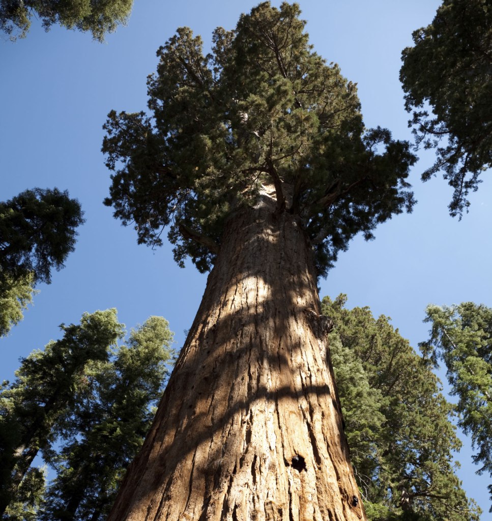
Kings Canyon National Park abuts Sequoia National Park; managed jointly by the National Park Service, both are also home to enormous trees. Formerly known as General Grant National Park, Kings Canyon is home to the General Grant Grove of Giant Sequoias, while Sequoia protects the Giant Forest and the General Sherman sequoia tree, the largest in the world. The colossal trees can be easily visited by car, but most of these parks are comprised of wilderness areas, with a diversity of landscapes running from the lofty heights of 14,491-foot Mount Whitney — the highest peak in the lower 48 states — to canyons, caves, and forests. Of the two parks, Kings Canyon is the more remote, entered by a single dead end road open in summer only. The parks are open all day and are popular year-round, but the busiest season is summer, specifically July and August, and campsites can fill up fast.
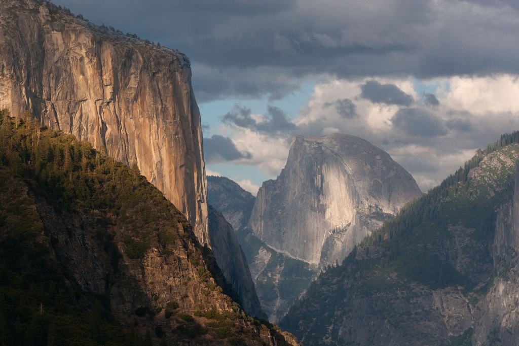
Yosemite National Park is beautiful year-round and a recreational wonderland in all seasons, but when you visit depends upon what you’re looking for. In the spring visitors can expect to find the waterfalls gushing and dogwood blooming. The Tioga and Glacier Point Roads often remain closed due to snow until late May, and tire chains are sometimes required even during the spring months. During the summer months everything is open and the park is often packed. The weather is hot and rivers have slowed with the decrease in snow melt. Gorgeous wildflowers bloom during June in the valleys and in July at higher elevations, a spectacle not to be missed. Water levels tend to be very low, with waterfalls (including Yosemite falls) containing little or no water. Some waterfalls, including Vernal, Nevada, and Bridalveil, run all year, however their flow slows to a trickle by fall. While Yosemite is not known for having spectacular fall colors because most of the trees are evergreen, big-leaf maples, black oaks, Pacific dogwoods, and other deciduous trees tend to be showy around mid-October. Come winter visitors can expect to find lots of snow and few people. Sunny and chilly days are not uncommon and trails in Yosemite Valley are often accessible. Snowshoeing and backcountry skiing are great ways to experience the park this time of year. If visitors want to try their luck and are feeling bold, they can enter a lottery to be one of the few who get to climb Yosemite’s iconic Half Dome.
Once you have narrowed down which parks you want to visit during which seasons, it’s time to download the right Chimani apps so that you can have all the information you’ll need in one place. Chimani’s National Park apps are designed to make it as simple and easy as possible for you to navigate around the parks and get the most out of your visits.
Each app’s map displays topographic information, roads, and — most importantly — clickable tabs that will take you to every hiking trail, scenic viewpoint, bus stop, restroom, food and lodging facility, and point of interest in the park. If something is in the park you can find it on the map! The apps also offer an excellent trip planning platform which helps users structure their own personalized excursions. Why wait? Download the free Chimani apps for each of California’s national parks today and start planning your next adventure!
